0
 0
A series of powerful low-pressure systems is currently sweeping across the North Atlantic toward Europe, bringing unsettled weather and drawing the attention of meteorologists. Particularly striking is the speed at which some of these systems are intensifying, leading experts to classify them as so-called “bomb cyclones.”
According to meteorologist Jan Schenk of The Weather Channel, the climate phenomenon El Niño may be contributing to the atmospheric conditions that favor the development of these exceptionally strong storms.
What Are Bomb Cyclones?
Despite the dramatic name, a bomb cyclone is a well-established meteorological phenomenon. The term refers to a rapidly intensifying low-pressure system that undergoes a process known as “bombogenesis.”
During bombogenesis, atmospheric pressure at the center of a storm drops unusually fast within a short period. This rapid pressure fall can significantly strengthen winds and increase the storm’s overall intensity.
Such developments are particularly common over the North Atlantic, where vastly different air masses frequently collide. Meteorologists often identify the waters south of Newfoundland as a key breeding ground for powerful extratropical storms.
Why Storms Are Strengthening So Rapidly
One of the main drivers behind the current storm activity is the sharp contrast between cold polar air and warmer air masses from lower latitudes. While cold air from Greenland pushes southward, warm and moisture-rich subtropical air moves north across the Atlantic.
When these contrasting air masses meet, conditions become favorable for the formation and rapid intensification of low-pressure systems. Additional energy is supplied by the warm waters of the Gulf Stream, which enhance evaporation and increase the amount of moisture available in the atmosphere.
According to Schenk, these temperature differences are currently particularly pronounced, creating an ideal environment for powerful storm development.
Jet Stream Reaches Up to 400 km/h
Another crucial factor is the jet stream, a narrow band of extremely strong winds high in the atmosphere that influences the movement and development of weather systems around the globe.
The greater the temperature contrast between warm and cold air masses, the stronger the jet stream can become. The Weather Channel reports that wind speeds within the jet stream are currently reaching as high as 400 kilometers per hour.
These extreme winds occur several kilometers above the Earth’s surface and should not be confused with surface wind gusts. However, a strong jet stream can significantly support the development and intensification of Atlantic storm systems.
El Niño’s Influence on the Weather Pattern
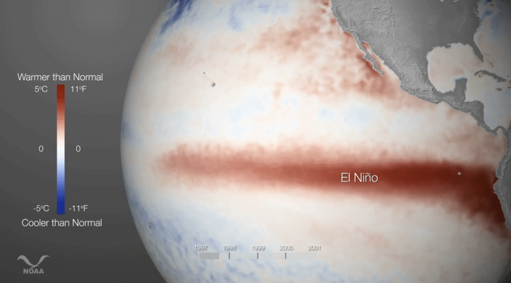
El Niño, the periodic warming of surface waters in the central and eastern tropical Pacific Ocean, is also believed to be playing a role in the current atmospheric setup.
Although the phenomenon occurs far from Europe, El Niño can alter large-scale circulation patterns across the globe. According to Schenk, El Niño tends to favor specific pressure configurations over North America during autumn and winter.
Under these conditions, strong high-pressure systems may develop over parts of North America while a pronounced low-pressure area forms near the Aleutian Islands in the North Pacific. This pattern can help drive cold air farther south along North America’s east coast while simultaneously transporting warmer air northward.
The result is an enhanced temperature contrast over the Atlantic, creating favorable conditions for explosive storm development.
Meteorologists emphasize, however, that El Niño does not directly cause these storms. Rather, it can create atmospheric circumstances that make the formation of particularly intense low-pressure systems more likely.
Impact on Europe and Austria
The current succession of Atlantic storms is already influencing weather conditions across parts of Europe. According to reports from The Weather Channel, Storm “Luise” is expected to reach Germany on Friday, October 23, while additional powerful Atlantic systems are forecast to develop in the coming days.
The situation highlights the strong connection between Atlantic weather systems and conditions across Europe. Storms that form over the ocean are often carried eastward by prevailing westerly winds, shaping weather patterns across the continent for several days.
For Austria, the key question remains how these low-pressure systems evolve and what paths they ultimately follow. At present, meteorologists are closely monitoring developments, but there is no confirmation of a specific severe storm threat for Austria.
Why Experts Continue Monitoring the Situation
Forecasters also point to relatively warm sea-surface temperatures in the North Atlantic as another factor that may be supporting stronger storm development this year.
In addition, The Weather Channel notes that the Atlantic hurricane season has produced relatively few hurricanes, while ocean waters remain unusually warm. These factors may be contributing to the current atmospheric dynamics.
Ultimately, the atmosphere is constantly attempting to balance temperature differences between warmer and colder regions of the planet. Low-pressure systems play a central role in that process. How intense individual storms become, and which parts of Europe may be affected, will depend on their future evolution and track over the coming days.
For now, meteorologists across Europe continue to watch the North Atlantic closely as an active storm pattern unfolds.
- source: vienna.at/picture: canva.com



This post has already been read 6 times!